cabral moncada leilões 191 | 27 de Novembro de 2017
181
380
M
apa do
i
Mpério
r
usso
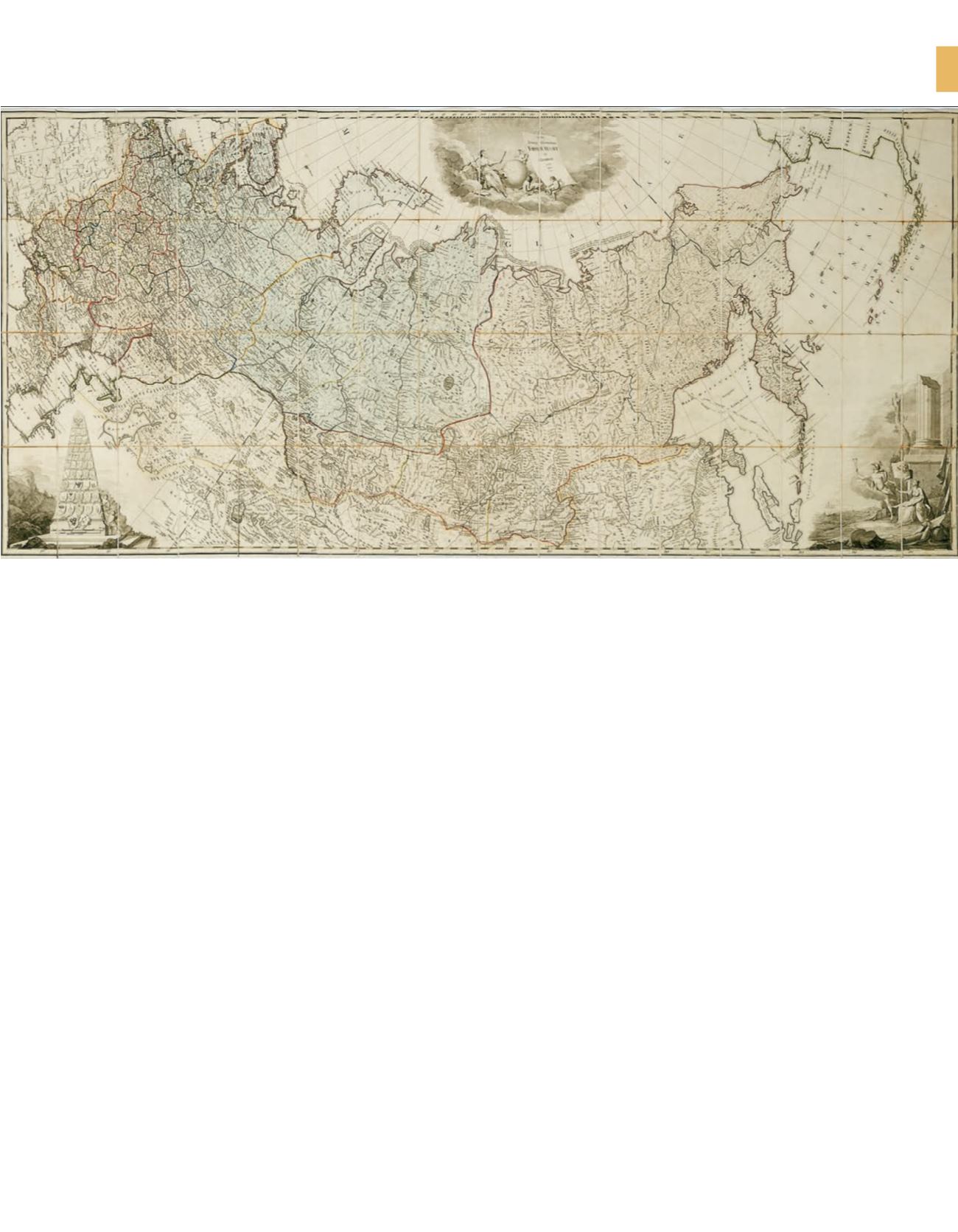
Nova Tabula Geographica Imperii Russici in Gubernia Divisi. [S.l.,
s.n.]. Edita, 1787., Monumental mapa (de campanha) da Rússia,
datado de 1787, gravado a talhe-doce, composto por 64 partes
ou folhas (cada uma com ±21 x 11 cm), montadas sobre tela, com
as dimensões totais de cerca de 84 x 187 cm.
De gravador e cartógrafo desconhecidos (não tem qualquer
subscrição), representa, com grande rigor e colorido periférico
manual, toda a extensão do Império Russo no reinado de Catarina
a Grande (1762-1796), desde o Mar Negro até ao Alaska, no
continente Norte Americano. A Nação Russa está dividida em
províncias ou gubernias, divisões administrativas do Império Russo.
Para além da imagem subjacente ao título, inclui, no canto inferior
esquerdo uma representação de um grande obelisco com os brasões
das principais cidades russas e, do lado direito, uma alegoria
à Rússia, representada por uma figura feminina com um mapa
desdobrado sobre o colo, o escudo russo a seus pés e a bandeira
imperial com a águia bicéfala na mão direita, dirigindo o seu olhar
ao deus Hermes da mitologia grega.
Em muito bom estado, o exemplar conserva o estojo original
em papelão revestido de papel marmoreado (21,8 x 12,5 x 3,5 cm)
e apresenta uma inscrição manuscrita à pena (por baixo do título):
Para a Secretaria de Estado dos Negócios Estrangeiros, 21 de
Dezembro de 1787. Nesta data reinava D. Maria I (1777-1815)
e era Secretário de Estado dos Negócios Estrangeiros Tomás Xavier
de Lima Teles da Silva (1727-1800), marquês de Ponte de Lima
e visconde de Vila Nova de Cerveira.
British Museum catalogue of printed maps, charts and plans,
vol. 12, p. 472; Catalogue of the maps and charts in the Library
of Harvard University, p. 23.
€ 1.200 - 1.800
M
ap oF the
r
ussian
e
Mpire
Nova Tabula Geographica Imperii Russici in Gubernia Divisi.
[S.l., s.n.]. Edita, 1787., Monumental Russia map, dated 1787,
intaglio engraved, consisting of 64 pieces or leaves(each
measuring ± 21 x 11 cm), mounted on canvas, with a total
size of about 84 x 187 cm. He is an unknown engraver and
cartographer (he does not have any subscription),
he represents, with great rigor and colourful peripheral
manual, the whole extension of the Russian Empire in the
reign of Catherine the Great (1762-1796), from the Black Sea
to Alaska, North America. The Russian Nation is divided into
provinces or gubernias, administrative divisions of the
Russian Empire. In addition to the image underlying the
title, includes in the lower left corner a representation of
a large obelisk with the coats of arms of the main Russian
cities and, on the right, an allegory to Russia, represented
by a female figure with a map unfolded on the lap , the
Russian shield at his feet and the imperial flag with the
two-headed eagle in his right hand, directing his gaze to
the god Hermes of Greek mythology. In very good condition,
the copy preserves the original cardboard case covered with
marbled paper (21.8 x 12.5 x 3.5 cm) and presents a pen
handwritten inscription (below the title): For the Secretary
of State of Foreign Affairs, 21 December 1787. British Museum
catalogue of printed maps, charts and plans, vol. 12, p. 472;
Catalogue of the maps and charts in the Library of Harvard
University, p. 23.


